

FLOOD RISK
Flood risk in the Lower Fraser is the result of historic land use decisions, aging infrastructure, and a changing climate. Addressing it now requires rethinking how we manage floodplains to better protect communities, ecosystems, and the region’s future.
A Floodplain Shaped by History
Water, governance, and shared responsibility in the Lower Fraser
For thousands of years, the Lower Fraser floodplain sustained salmon, local food systems, and the cultural relationships of Coast Salish First Nations. Communities lived with the river’s seasonal rhythms. Floodwaters spread across wetlands and side channels, nourishing spawning grounds, replenishing soils, and sustaining plants and wildlife that supported thriving villages.
Flooding was not simply a hazard. It was part of a living system.
That balance changed with colonization.
Beginning in the late 19th century, governments reshaped the floodplain through dikes, drainage systems, railways, and roads. Wetlands were filled. Rivers were confined. Sumas Lake — once a vast natural flood storage basin and critical salmon habitat — was drained. Natural spillways that once absorbed and slowed floodwaters were cut off, increasing pressure on downstream communities.
These decisions were made without the consent or leadership of First Nations, and without understanding the long-term ecological consequences. Salmon habitat declined. Wetlands disappeared. First Nations communities bore disproportionate impacts as food systems, cultural sites, and flood storage areas were altered or lost.
Governance became fragmented as well. Over time, responsibility for flood management shifted largely to municipalities and local districts — even though no local authority had the funding, jurisdiction, or mandate to manage a hydrological system as large and interconnected as the Lower Fraser. Maintenance varied. Land use decisions were made in silos. Weak links developed across the dyking system.
Today, we live with the cumulative effects of those choices.
Much of the floodplain has been converted to agricultural and urban land, yet it remains active floodplain — and the traditional territories of Lower Fraser First Nations. Aging infrastructure protects communities that are more exposed than ever. Climate change is intensifying river flows, sea level rise, and extreme rainfall, amplifying every existing vulnerability.
The BC Flood Strategy offers a pathway toward watershed-based planning, disaster risk reduction, and climate adaptation. But implementation remains unfunded, and communities are still waiting for guidance and governance reform that align with the United Nations Declaration on the Rights of Indigenous Peoples (UNDRIP) — including shared decision-making and respect for Indigenous rights, title, and knowledge systems.
Flood resilience in the Lower Fraser cannot be addressed one project at a time or one municipality at a time. It requires basin-wide coordination, sustained federal investment, and governance structures that reflect the scale of the river itself. It requires restoring natural flood storage, reconnecting waterways across the floodplain, and advancing multi-benefit solutions that protect communities while rebuilding salmon habitat and supporting food security.
Most of all, it requires moving from fragmented management to shared leadership grounded in reconciliation.
The timeline below traces major floods and the policies that followed them — showing how river forces and human decisions together shaped today’s risks, and why the future requires working differently.


Current Challenges
Flood risk in the lower Fraser is increasing, but our ability to respond is limited by aging infrastructure, historical land-use decisions, fragmented governance, and the accelerating impacts of climate change. These challenges affect communities, ecosystems, farms, cultural sites, and critical services across the region.

Cost of Inaction
The November 2021 atmospheric river event demonstrated the devastating consequences of unprepared flood systems in British Columbia.
Two powerful atmospheric rivers brought record rainfall to southwestern B.C., triggering catastrophic flooding, landslides, and infrastructure failures.
Major highways and rail lines were severed, temporarily isolating Metro Vancouver from the rest of Canada. Over 1,100 homes were evacuated, five lives were lost, and thousands of livestock perished in the Fraser Valley.
Insured losses reached approximately $675 million, with total economic losses estimated in the billions of dollars, making it one of the most costly disasters in provincial history.
Extreme flooding continued in late 2025, when intense rainfall of up to 145 mm in parts of the Fraser Valley again caused widespread flooding, highway washouts, local states of emergency, and additional fatalities.
Repeated flooding has meant repeated rebuilding — damaged farms, washed-out highways, disrupted supply chains, and millions spent restoring infrastructure that remains vulnerable to the next storm.
These events make clear that flood risk in the region is no longer hypothetical. Climate-driven atmospheric rivers are increasing in intensity, and without coordinated adaptation, infrastructure investment, and governance reform, the social, ecological, and economic costs will continue to escalate.
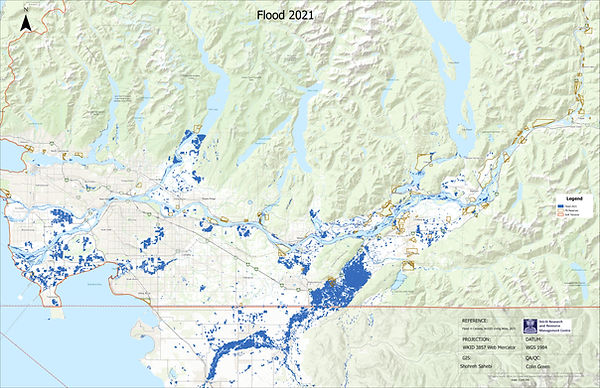
Flooding during the 2021 atmospheric river -
map created by the Stó:lō Research and Resource Management Centre

Flooding during the 2025 atmospheric river -
map created by the Stó:lō Research and Resource Management Centre
Our Response
“‘How do we protect people, our region, and our economy in the most effective way possible?’

Together, this approach expands our flood management toolbox and supports collaborative, strategic, and integrated decisions for the Lower Fraser.
Our Progress
We advance regional flood resilience through technical analysis, shared mapping, and coordinated planning across the Lower Fraser. Our work brings together First Nations, local governments, and partners to align priorities, strengthen decision-making, and move from dialogue to implementation. Explore the projects that are building safer, more resilient floodplains.
